ACE 2026 - September 8th
 The bimonthly news publication for aviation professionals.
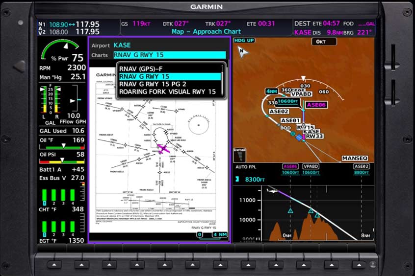
Garmin has partnered with Hughes Aerospace to launch Guided Visual Approaches, a purchasable database providing three-dimensional lateral and vertical guidance for visual procedures at 25 airports across the US. A total of 31 approaches are now available on flyGarmin.com and will be included in the OnePak bundle from 7 August 2025.
Each procedure offers autopilot-coupled guidance similar to RNAV approaches and can be loaded and activated like standard instrument approaches. Charts are georeferenced and accessible via Garmin FliteChart or the Hughes app. Compatible avionics include Garmin WAAS-equipped navigators capable of RF legs, such as the GTN and GTN Xi series, and selected integrated flight decks.
Garmin’s director of airline and business aviation sales, Creighton Scarpone, says: “We are confident these approach procedures will help simplify approaches for pilots who often find themselves in challenging terrain or airport environments.”
Chris Baur, CEO of Hughes Aerospace Corporation, adds: “Guided Visual Approaches deliver precise, three-dimensional navigation to the runway threshold, enhancing safety, reducing pilot workload and maximising the value of your Garmin avionics investment.”
These procedures are intended to increase stability for turbine aircraft and aid night-time city approaches where visual references are often difficult.