


ACE 2026 - September 8th
 The bimonthly news publication for aviation professionals.
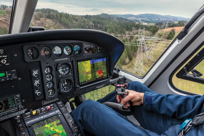
Garmin's G500H TXi touchscreen flight display is now certificated and available for normal category VFR helicopters. The G500H TXi offers an array of panel possibilities and a streamlined upgrade path for helicopters already equipped with the original G500H flight display. Additionally, a new software version for the GTN 650/750 series has been approved for helicopters. “Based on the success and adoption rate of the original G500H series, we’re excited to bring the next generation G500H TXi displays to the helicopter market,” says Carl Wolf, vice president of aviation sales and marketing. “The growth-oriented G500H TXi boasts innovative features with vibrant graphical displays and greater situational awareness tools, and when paired with the GTN, pilots receive a harmonious avionics suite that adds even more capability in the cockpit.”
Designed specifically for normal category VFR helicopters, the G500H TXi is available in several sizes and formats, including a large 10.6-inch touch-controlled display and two versions of seven-inch touch-controlled displays in either portrait or landscape orientations. Both displays offer concentric knobs for added versatility and convenience. The 10.6-inch G500H TXi is available in a horizontal format that can accommodate PFD information and an MFD simultaneously. The seven-inch portrait display can be individually dedicated to a PFD or MFD. For space-limited panels, the seven-inch landscape display can serve as a dedicated PFD with instrument tapes and an arc-view horizontal situation indicator (HSI). The G500H TXi also features multiple video input options, night vision goggle (NVG) compatibility and a graphical map overlay within the HSI for most display formats.
The G500H TXi incorporates a clean-sheet touchscreen design with modern processors that support improved map and chart rendering, faster panning and contemporary single-finger zoom and pinch-to-zoom gestures. For helicopters already equipped with the original G500H series flight display, full G500H TXi compatibility with existing system sensors, Garmin says, makes for an easy, cost-effective upgrade path. For a limited time, Garmin is offering a display upgrade programme.
The G500H TXi is equipped with five-colour Helicopter Terrain Awareness and Warning System (HTAWS), WireAware wire-strike avoidance technology, as well as optional Garmin HSVT 3D synthetic vision. HTAWS offers forward-looking avoidance capability and predicts where potential hazards may exist to help pilots maintain safe separation from nearby terrain, towers or obstacles. A helicopter-specific obstacle database contains over 200,000 additional low-altitude obstacles. For added protection, an expanded version is also available and offers over 700,000 miles of power line data. Garmin WireAware wire-strike avoidance technology uses this database to overlay powerline locations and relative altitude information on the moving map and provides both aural and visual alerting when operating near powerlines.
Connext cockpit connectivity with Flight Stream 510 and added Database Concierge is also available as an option with the G500H TXi. Using a compatible tablet or smart phone, pilots can upload and sync database information using the Garmin Pilot app. Additional features include the streaming of traffic, weather, GPS information and back-up attitude information, from the G500H TXi to the Garmin Pilot, FltPlan Go or ForeFlight Mobile applications.
Integration between the G500H TXi and the GTN 650/750 touchscreen navigators provides helicopter operators with touchscreen continuity between the navigation, communication and flight display interface in the panel. The latest software upgrade for the GTN 650/750 incorporates optional hardware compatibilities, new operational features and capabilities.
Pilots can now set a user-defined waypoint as an airport so terrain alerts are minimised while landing at an airport that is not in the aviation database. The addition of a QWERTY keyboard within the GTN 650/750 gives pilots a more familiar way to input information.
Pilots can configure comm sidetone settings within the GTN series, and Irish, Swiss and English coordinate systems are now supported so it’s easier for pilots to enter GPS coordinates in various formats, including latitude/longitude, degrees/minutes/seconds and decimal degrees.
The GMA 35c remote audio panel is now approved for use in helicopters with the GTN 750 so operators can take advantage of the convenience and utility associated with a Bluetooth audio panel. To aid in descent planning and energy management, pilots can take advantage of descent vertical navigation (VNAV) profiles within the GTN.
The G500H TXi comes with a two-year warranty and is available immediately. The GTN 650/750 software upgrade is also available immediately from authorised dealers.